Geography : Lao Cai Province is located in the north of the country. It is bordered by the provinces of Ha Giang, Yen Bai, Son La, Lai Chau and Yunnan province of the People’s Republic of China.
Lao Cai is a mountainous region. In the northwest of the province is Phan Xi Pang (a.k.a. Fansipan), Vietnam’s highest mountain. The province is divided in two parts by the Red River , the most significant river of northern Vietnam, which flows out of China towards the capital city of Ha Noi. Most area of the province is heavily forested. The temperature generally ranges between 18° and 28°, although lowland areas tend to have less variation than mountainous areas.
Area : 6,383.9 km²
Topographic features : Lao Cai is situated in the valley of Red river and Chay river with high mountain ranges, creating strongly partitioned topography. Its average high above sea level level varies from 80m to 3,000, typically the Hoang Lien Son mountain range with Fan xi pan top of 3,143m above sea level.
Administrative unit: Lao Cai is divided into Lao Cai city and 8 districts: Bao Thang, Bat Xat, Bac ha, Muong Khuong, Sapa, Si Ma Cai and Van Ban.
Population: 593.600 people
“Transportation system: Unlike other mountainous provinces, the province’s has a various transportation network including roadway, railway, and waterway. Now there are 4 national highways running through the province with the total length of 356km (National highways No. 70, 4D, 4E, 279). Besides, the rail line Hanoi-Lao Cai is linked to China. Despites of its limitation in waterway, Lao Cai has advantages for economic development thanks to its roadway and railway system.
Power supply system : The province’s power network has been improved. Lao Cai power authority is in charge of managing 55 km of double-circuit 100 kV, 27 single-circuit 100kV, 1,326 km of 0.4-35 kV including 706km of 35 kV, 2 100 kV transmission stations, 6 intermediary stations and 306 distribution transmission stations of all kinds.
Water supply and drainage system: Up to the year 2005, Lao Cai has Clean Water Enterprise No. 1, and 7 water supply stations in 6 districts: Bao Thang, Bao Yen, Sa Pa, Van Ban, Si Ma Cai, Bat Xat and in Cam Duong. Besides there are several enterprises operating in consultancy, construction of water drainage system. The total number of local commodity water is 3,393,000 m3 in 2004 supplying water to 60,000 persons 24/24h.
Post-telecommunication system: Postal services are available in centers of districts/townlets/communes in the province with over 300 post offices, nearly 100 commune cultural postal points. The telecommunication system has been developed with digital microwave and optical cable equipment. Telephones are used in 148/164 communes/wards/townlets. Mobile phones can be reached in 5/8 districts and Lao Cai city”
Sectors’ development plan:
+ Services: with its strength of a key point in the Northern west economic zone, Lao Cai will continue developing its multi-sectorial trade-service system, trade in urban areas, rural market network, goods specialized zones. In addition to this, Lao Cai will make plan for comprehensive development of tourism services, investing in infrastructure construction, conserving and upgrading places of interest together with diversifying its tourism services, developing unique, specialized ones, investing in human resource development, improving tourism management.
+ Agriculture-Forestry-Fishery: For the period 2006 – 2010, agriculture in Lao Cai will be developed with focus on quality, ensuring sustainable development. Lao Cai’s plan for forestry development will focus on changing forestry exploitation to effective socialization in forestry, developing small and medium size forestry processing industry using proper technology and centred materials zones.
+ Industry: Priorities will be given to developing industry-small scaled industry with focus on
mineral exploitation and processing, construction material production, construction of small-medium scaled industry zones, agricultural-forestry processing and preservation, medical plant growing, ensuring product purchasing sources for farmers’ crops, establishing goods centred zones, developing rural power supply network, hydro-electricity and other kinds of energy, restoring traditional professional villages, establishing professional villages producing handicrafts for export
Located 38km from Lao Cai City, Sapa is a mountainous district of Lao Cai Province. Sapa District is very well-known with Sapa Townlet, a beautiful and romantic resort.
At the height of 1,600m above sea level, the average temperature of the area is 15-18oC. It is cool in summer and cold in winter.
Visitor to Sapa in summer can feel the climate of four seasons in one day. In the morning and afternoon, it is cool like the weather of spring and autumn. At noon, it is as sunny and cloudless as the weather of summer. And it is cold in the evening. With no advance warning of a thunderstorm short and heavy rains may come at noon on any summer day. Subsequently, a rainbow appears, transforming Sapa into a magic land, which for years has been a constant source of poetic inspiration, lights up the whole region.
The best time to witness the scenic beauty of Sapa is in April and May. Before that period, the weather might be cold and foggy; after that period is the rainy season. In April and May, Sapa is blooming with flowers and green pastures. The clouds that settle in the valley in early morning quickly disappear into thin air.
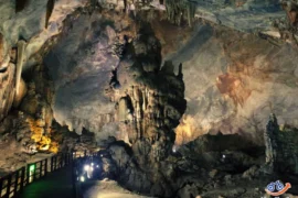
Sapa has many natural sites such as Ham Rong Mountain, Silver Waterfall, Rattan Bridge, Bamboo Forest and Ta Phin Cave.Sapa is also the starting point for many climbers and scientists who want to reach the top of Fansipan Mountain, the highest mountain in Vietnam at 3,143m. Hoang Lien Mountain Range is also called the Alps of the North Sea area since Fansipan Mountain is not only the highest peak in Vietnam, but also in the Indochina Peninsula. The pyramid-shaped mountain is covered with clouds all year round and temperatures often drop below zero, especially at high elevations.
The first thing you notice when approaching the resort town are some detached wooden mansions and villas perched on a hill top or hillside, behind thick pine forests and almost invisible on this foggy morning. Old and new villas with red roofs now appear and now disappear in the green rows of pomu trees, bringing the town the beauty of European towns.
Fresh and cool air in Sapa is an idea climate condition for growing temperate vegetables such as cabbage, chayote, precious medicinal herbs, and fruit trees such as plum, pear…
Sapa is home to various families of flowers of captivating colours, which can be found nowhere else in the country. When Tet, the Lunar New Year Festival, comes, the whole township of Sapa is filled with the pink colour of peach blossom brought from the vast forests of peach just outside the town. Sapa is regarded as the kingdom of orchids. Here, orchid lovers are even amazed by the choice, when trekking in the forest filled with several hundred kinds of orchids of brilliant colours and fantastic shapes, such as Orchid Princess, Orchid of My Fair Lady’s Shoe. Some orchids are named after lovely singing birds such as the canary, salangane’s nest, and more.
Sapa is most beautiful in spring. Apricot, plum and cherry flowers are splendidly beautiful. Markets are crowded and merry, and are especially attractive to visitors. Minority groups come here to exchange and trade goods and products. Market sessions are also a chance for locals to promenade and young men and women in colorful costumes to meet, date or seek sweethearts.
Visitors to Sapa will have opportunities to discover the unique customs of the local residents.