Quang Binh province is situated in the north of Central Vietnam. The northern of Quang Binh province is contiguous to Ha Tinh province, the Southern is contiguous to Quang Tri province, the Eastern is contiguous to the Eastern Sea, and the Western is contiguous to Laos.The province has a coastline of 116.04km in the East and shares a border of 201.87km with Laos in the West. It is the place where Hon La seaport is situated. The national Highway No.1A, Ho Chi Minh road and the north – south railways run through the province. The national road No. 12 and the provincial roads No. 20, No. 16 running from the east to the west connect the province with Laos through Cha Lo border gate and other sub-border gates.
Area : 8,055 km2
Topography: The provincial topography is narrow and sloping from the West to the East. Hilly and mountainous land occupies 85% of the natural area. The total area is divided into specific geological zones: mountainous, hilly and midland, lowland and coastal sandy area.”
Population: 854,918 people (2007)
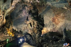
Culture and tourism potentials: Quang Binh land spreads out as a nice picture with mountains, sea, landscapes and famous spots as Ngang pass, Ly Hoa pass, Nhat Le estuary, Hac Hai lagoon, Cong Troi (Heaven gate), etc., especially, the natural heritage of Phong Nha – Ke Bang.
Quang Binh is the land of rich culture and famous people. There is an archaeological site of Bau Tro, Hoa Binh and Dong Son cultures. There are also many historical relics such as Quang Binh Quan, Luy Thay, outer walls of Trinh – Nguyen, well-known places in the wars as Cu Nam, Canh Duong, Xuan Bo, Cha Lo, Cong Troi, Gianh river, Long Dai, especially Ho Chi Minh legendary trail. This land has generated preeminent figures such as Duong Van An, Le Thanh Hau Nguyen Huu Canh, Nguyen Ham Ninh, Vo Nguyen Giap and many other outstanding people.
Transportation system: It is quite convenient to travel in/from/to Quang Binh with North-South railway route, national highway No. 1A and Ho Chi Minh route running through most of the province’s residence areas and areas which are potential for development. National highway No. 12A connects its Cha Lo – Na Phau international border gate with Middle Laos and Northern East of Thailand. Besides, the province has 116km of coastal line. Nhat Le and Gianh ports allow the circulation of 5,000 ton ships. Hon La deep water bay which can be developed into port allowing the circulation of 30,000-50,000 ton ships . Dong Hoi airport helps to support economic, tourism development.