Thanh Hoa province is situated in the north central of Viet Nam with its geographical position from on the 19°18′ to 20°40′ of the northern latitude and from on the 104°20′ to 106°5′ of the eastern longtitude. Bordering with Hoa Binh, Son La, and Ninh Binh province inh, Nghe An province in the south, Hua Phan province of Laos PDR in the west and the East Sea in the east with more than 102 km coast. The width from the West to East is 110km, from North to South is 100km. Thanh Hoa is 150km away from Ha Noi capital, 610km from Da Nang city and 1560km from Ho Chi Minh city.
Area: 11,136.3 km2
Topographic features: The province has various topography lower from the West to the East and divided into 3 areas: mountains and midland with the area of over 8,000km2, plain whose level is raised by rivers (Ma river, Chu river, etc.), and coastal areas such as Nga Son, Hau Loc, Hoang Hoa, etc.
“Administrative divisions:
It is divided into 1 city (Thanh Hoa city), 2 towns (Bim Son, Sam Son) and 24 districts: Ba Thuoc, Cam Thuy, Dong Son, Ha Trung, Hau Loc, Hoang Hoa, Lang Chanh, Muong Lat, Nga Son, Ngoc Lang, Nhu Thanh, Nhu Xuan, Nong Cong, Quan Hoa, Quan Son, Quang Xuong, Thach Thanh, Thieu Hoa, Tho Xuan, Thuong Xuan, Tinh Gia, Trieu Son, Vinh Loc, Yen Dinh.”
Population: 3,697,200 (Statistics Yearbook of 2007)
Tourism
Located 16km from Thanh Hoa City, Sam Son Beach attracts lot of visitors to relax and bath. Beside the beach, Sam Son offers scenic spots such as Trong Mai Rocks, Doc Cuoc Temple and Mount Co Tien.
Tourists also like to discover Ben En National Park in Nhu Thanh, Nhu Xuan districts. The park is a complex of tropical forests, hills, mountains, rivers, springs, and Muc Lake. With natural landscapes and diversified flora and fauna, Ben En is suitable to eco-tourism, sightseeing, and scientific studies.
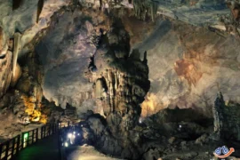
Cam Luong Fish Spring is another interesting place in Thanh Hoa, The stream contains thousands of fish that no one dares catch it. Fish in the stream have red mouth and fins, and brown scales, resembling carp. Please come to this place to play with fish, visit beautiful caves and grottos, watch dancing performances of Muong people and enjoy traditional lam rice and can wine.
In addition of these, Thanh Hoa is famous of historical vestiges like Ham Rong Bridge, Ho Citadel and Lam Kinh Remains. Lam Son is the birthplace of national hero Le Loi and the starting point of the Lam Son revolutionary insurrection.
Resources
– Natural resources: The province’s agricultural area is approx. 245,367 hectares with types of lands suitable for developing crops, timbers, industrial crops and fruit trees. Besides, it has one of the largest forestry resources with the area of 484,246 and annual possible exploitation of 50,000 – 60,000 m3 (the wood reserves is16.46 million m3). It also has diversified mineral resources with 296 mines and ore points, 42 different mineral types, some have big reserves such as granite stone, marble, limestone for making cement, etc.
– Human resources: The province’s population was 3.67 million in 2005. The number of people of working age was approx. 2.16 million, accounting for 58.8% of the population. It has quite young workforce with fairly education. Trained labourers account for 27% including 5.4% graduates of college, university and above.
”
Transport: It is convenient to travel in/to/from Thanh Hoa with its system of railway, roadway and waterway. The province has 92km of North-South railway route with 9 stations, convenient for goods and passengers transportation. Besides, there are several national highways (national highways no. 1A, 10, 15A, 45, 47, 217 and Ho Chi Minh route) running through the province. The province has 1,600km of river line with Le Mon port (6km from Thanh Hoa city), its annual capacity is 3000,000 tons. Nghi Son deep water sea port which can allow the circulation of ships of 5 tons and above has been developed to become a key point for storage and international transportation.
– Power supply system: The system has been improved both in quantity and quality, ensuring stable supply to households and production units. The local national power network include 508 km of high voltage lines, 3,908 km of medium voltage lines and 4,229 km of low voltage lines, 9 110/35/6-10 KV transformer stations, 38 intermediary stations, 2,410 distribution stations. Up to now all city, towns, districts, 94% of communes, 91% households have access to the snational power network.
– Water supply system: The system has been improved to meet the increasing demand of households and production units, especially in city, towns, districts, townlets and industrial zones. There are 2 existing water supply plants which are Mat Son and Ham Rong. One more is being built to supply water to Nghi Son, Le Mon industrial zones and townlets.
– Post and telecommunication system: Over the past few years, the system has been strongly developed and expanded. At present, 598 out of 636 wards, communes, townlets have telephone network, accounting for 94%, 26 out of 27 city, town, districts have access to mobile phones. It is planned to have mobile phone network in all parts of the province in 2010. The number of telephones per person has been increased (8.69 telephones/100 persons in June 2006).
en.vietnamexport.com